About GPS and Electronic Charts 

How GPS Works  -  DGPS Chart Datum  -  Converting Chart Datum

The selections below are protected by copyright and are not to be reproduced or distributed without permission of the copyright holder.

How GPS Works

The Global Positioning System (GPS) is a world-wide 24 hour navigation positioning system operated by the US Department of Defence. It consists of a Ground Control Segment, a Space Segment and a User Equipment Segment. The User equipment segment is what is commonly known as a GPS receiver.

24 earth-orbiting satellites in six different orbits form the Space Segment . (There are also 3 or 4 operational spares in orbit at any one time.) Each satellite circles 10,900 nautical miles above the earth in orbits inclined at an angle of 55 degrees to the equator. Each satellite transmits precision timing signals (derived from onboard atomic clocks) on two frequencies, L1 and L2. A separate channel on each frequency is dedicated to each satellite.

The navigation messages broadcast on the L1 frequency contain two codes, one for civilian use, and another encrypted code for military use. The L2 broadcast contains a second set of navigational messages, which when combined with the encrypted code in the L1 frequency, can resolve positions to less than 20 meters. Known as the Precise Positioning Service (PPS), this service is available only to the US military, and its allies.

The non-encrypted codes in the L1 frequency, (available to civilian users), provide the Standard Positioning Service (SPS). When GPS was in its initial testing phases it was found that this service provided position fixes that were far more accurate than was originally intended, so SPS accuracy was intentionally degraded by the introduction of random errors in the timing signal--reducing the position fixing accuracy of GPS to 100 meters 98% of the time. This intentional degradation of the timing signal was known as Selective Availability (SA), and constituted over half the total GPS error prior to May 1, 2000. (The satellite clock need only be "dithered" by a few millionths of a second to create the desired effect. That is why, in spite of SA, GPS time is the most accurate clock you will have on board your vessel.)

However, recognizing the importance of GPS to the civilian economy, the United States Government removed Selective Availability on May 1, 2000. Now the single largest contributor to GPS error is interference with the broadcast signals caused by the ionosphere (a shell of electrically charged particles that surrounds the earth.) Now a GPS position is expected to be accurate within 20 meters.

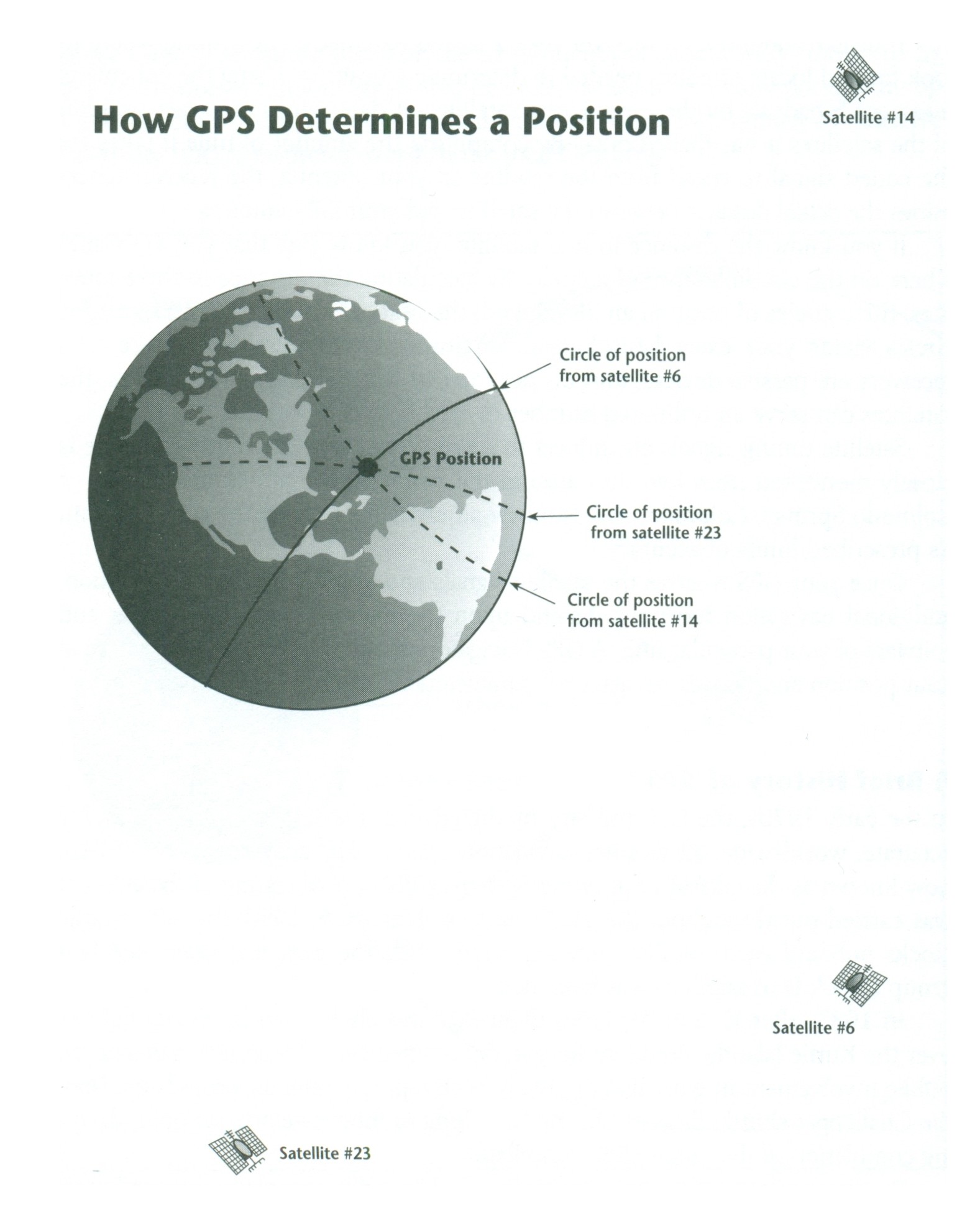
Each satellite also broadcasts "Almanac" and "Ephemeris" messages. Your earthbound GPS receiver uses the almanac to determine which satellites are above the horizon and what channels they are broadcasting on. The receiver then locks on to the most appropriate satellites for fixing a position. 

Given the exact time the navigation message was broadcast, and knowing the time it was received, the GPS receiver determines the amount of time it takes for the coded signal to travel from the satellite to your antenna. From there it is a simple computation to determine the actual distance between the satellite and your GPS antenna.

From this point, the GPS receiver calculates a position in the same way as a human navigator using radar ranges. The ephemeris message tells the receiver the exact location of the satellite when the message was broadcast, and since the receiver now knows the distance to the satellite, it calculates that it must be on the surface of an imaginary sphere, centered on the satellite. Where that sphere intersects with the surface of the earth, a Circle of Position ( COP) is formed.

From two satellites the receiver calculates two COP's, which cross at two possible positions. To determine which position is the correct one, a third satellite range is needed. Thus, for a receiver at sea level, a minimum of three satellites are needed to determine a two-dimensional position. For aircraft, and vehicles on land, which operate above sea level, a fourth satellite is needed to determine a three-dimensional position (including altitude).

Satellite timing signals are subject to small errors, so each orbiting satellite is closely monitored from five sites around the world (The Ground Control Segment). The main control facility at Falcon Air Force Base, Colorado, makes minor adjustments to keep the system within its prescribed limits of accuracy--(20 meters).

From GPS--Instant Navigation  2nd Edition

DGPS

Note: In 2022 Differential GPS was discontinued in Canada, the United States, the UK and Ireland

Return to top of page

Chart Datum

From GPS--Instant Navigation, Second Edition, Chapter 3, by Kevin Monahan and Don Douglass

Not only may charts be subject to small errors in the location of certain geographic features such as shorelines, isolated rocks, shoals and the like, but they may also contain large systematic errors due to inaccurate determination of latitude and longitude.

As an example, certain islands in the South Pacific Ocean actually lie many miles from their charted positions because their discoverers made errors in computing latitude and longitude—especially longitude. When you consider that accurate determination of longitude depended on the ship’s captain accurately tracking the error of his chronometer for two years or more, it is wonderful that we can make any sense at all out of these older charts.

In the Strait of Magellan, one of the authors noted discrepancies of 0.7 Nm to 1.1 Nm between the charts and his GPS position. On British Admiralty charts the largest known difference is 9 miles.

These errors developed because there was no single reference point to which charted features could be compared. For instance, when charting a South Seas lagoon, a nineteenth century surveyor could only reference the chart to a datum point somewhere on the shore of the lagoon; he could not accurately position that datum point in relation to the surface of the earth. What he needed was a single datum point somewhere on the earth’s surface to which he could reference his charts. Although such a datum point did exist (the Royal Observatory at Greenwich, England), it was too far away to be used as an accurate reference for the chart, so the surveyor had to make do with a local datum.

Since that time, cartographers and hydrographers have continued to attempt to define local datums that are relevant over larger and larger areas. In order to do so, they have used measurement systems that maintain accuracy over greater distances but, when crossing bodies of water, these systems break down because there is no fixed ground in which to set survey stakes. Consequently until the arrival of satellite positioning, map datums were limited to continental-sized areas.

An additional problem arises when a hydrographer attempts to extend a datum over a large area. The earth is not a true sphere; it is flattened at the poles and has lumps, bumps, and depressions. The surface of the ocean, likewise, does not follow an ideal spherical shape. Local differences in the force of gravity cause parts of the world’s oceans to be more than one hundred meters higher or lower than others, refuting the idea that there is a perfect "sea level" to which heights can be referred.

Hydrographers and cartographers must make assumptions about the shape of the earth when they draw their maps so, in 1927, North American hydrographers began to use a standard set of assumptions about the earth’s shape which applied to all North American charts. This standard model is known as a "geodetic system," "chart datum," or "horizontal datum." In North America it is known as North American Datum 1927 or NAD27 (not to be confused with tidal datum which is the zero tide level). In other parts of the world, surveyors have established different datums.

Since 1927, cartographers have learned more about the shape of the earth, and in 1983, using satellite telemetry data they established a new datum (NAD83) in North America. Among its many features, it makes allowance for changes in their understanding of the shape of the earth’s surface that introduced errors of up to 200 meters in NAD27. When charts were drawn to the new datum, cartographers discovered that the positions of geographic features on charts drawn to the older datum could not be reconciled with their positions on new charts—the lines of latitude and longitude on the older charts were in the wrong places. In many areas of the continent, these differences are minimal—just a few meters—but in other areas the difference between NAD27 and NAD83 is over 200 meters (more than 0.10 Nm). Displacement of position due to datum differences is called datum shift.

These discrepancies didn't matter when navigation systems were less exact, but with the advent of precise positioning, cartographers began to take these datum shifts seriously. Notices suddenly appeared on charts indicating the datum to which the chart was drawn, as well as the degree of correction to be applied to older charts to reconcile them with the new navigation systems. Now that worldwide satellite positioning is available, GPS uses a truly universal chart datum—World Geodetic Survey 1984 (WGS84). In North America, WGS84 is equivalent to NAD83.Boaters operating in northern British Columbia and southeast Alaska may find discrepancies of up to 200 meters. On older charts of Dover Strait, charted to the 1936 Ordinance Survey of Great Britain (OSGB), the shift is approximately 140 meters. Unless you resolve these differences, your GPS receiver will lose some of its usefulness.

Converting from One Chart Datum to Another

Since many parts of the world are charted using the old datums, hydrographic agencies are now adding notices on older charts indicating the horizontal datum and the required corrections to be applied to a GPS position before you plot it on a chart. When new surveys are conducted and a new chart issued, it is drawn to WGS84, and a datum note is incorporated. If you are using an electronic chart system, the chart itself should already have been registered to the WGS84 datum, even raster charts that carry a horizontal datum notice that they were drawn to NAD27!!

Before you plot GPS-derived WGS84 co-ordinates on a paper chart drawn to a local datum, you will have to apply corrections either to your plot or to the GPS receiver itself. If you decide to correct the co-ordinates manually, you will find it a cumbersome process. If you want to lift positions off a chart not drawn to WGS84 or an equivalent datum, and you wish to use the co-ordinates with a GPS set to WGS84, you will have to perform the conversion in reverse. If no horizontal datum is noted, you may be able to find the corrections in the issuing agency’s Notices to Mariners. But you should be aware that there are some charts that have been drawn to an unknown datum. When these charts are rendered into raster electronic charts, they may not display positions correctly. 

To the right is a screen-capture of a series of tracklines displayed by an electronic chart system against a chart drawn to an unknown datum. Clearly the chart is in error, and the vessel did not pass over land. Someone would have noticed!!

Manufacturers of GPS receivers are aware of chart datum problems and have gone to great lengths to include corrections for over 100 datums in their software. (See Appendix I of GPS--Instant Navigation for a list of 151 datums, of which approximately 100 are used on nautical charts.) Simply select the correct datum when working with any particular chart and the receiver will then display lat/long co-ordinates consistent with the charted position. This is the method most skippers use, and it certainly simplifies things.

If you want to make the conversions with your GPS, you must ensure that the chart datum being used by the GPS at any one time matches that of the chart you are using. This means that you must check every chart you use and, if necessary, reset the GPS every time you move from one chart to another. The value of your GPS as a precision navigation tool will be seriously compromised if you fail to do so.

Remember: Corrections used on one chart may not be the same as those for a chart of another nearby area drawn on the same datum. However, modern receivers include most of the common datums in use worldwide—some software packages contain over 100 choices.

Return to top of page


Web pages copyright © 2023 Shipwrite Productions

Last updated August 2023